Tourist Maps: How Cities Hide Their Blemishes
Hi folks! I just spent a lovely weekend in Portland, Maine (not to be confused with Portland, Oregon, another cool city 3192 miles west). Although there are plenty of interesting urban planning details to remark on, for the moment I want to talk a bit about my experience walking around the city.
I stayed at the Portland Hilton, a really cool hotel on the east end of the downtown port. Like most cities, Portland has a tourist-friendly cartoon map of its downtown. These maps are available, for free, in most of the major downtown businesses and hotels. Armed with one of these maps (pictured below), I set off exploring downtown.
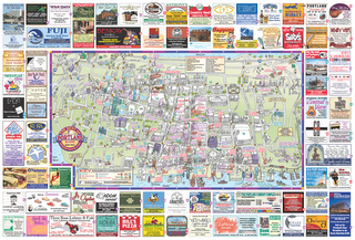
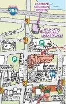
I made my way from the hotel (bottom right) to the public library (top center). Craving dried cranberries, I noticed that, according to the map, there is a Wild Oats just north of the public library:

As you can see from the map, it would appear that Wild Oats is but a mere two blocks north of the public library. Thus, confident in my navigational skills I set off for a quick jaunt. Little did I know that not only was the tourist map not drawn to scale, it actually omitted entire roads!
Why is this important? Because the seemingly short trip between the public library and Wild Oats was actually a ten-minute trek through six blocks of a fairly rundown section of Portland. These blocks included homeless shelters, assorted support services for those folks, and so on. To top it off, there were anti-cruising notices posted, a clear sign of drug activity in the area. (A brief excerpt from the relevant law: "(a) No person shall drive or permit a motor vehicle under that person's care, custody, or control to be driven past a traffic-control point three (3) times within a two-hour period in or around a posted 'no cruising' area.").
Let's be realistic: all cities have their run-down neighborhoods (consider Cleveland, Boston and Chicago). Was I really surprised to discover that Portland does as well? Certainly not, but I was surprised that a tourist map would not only gloss over those areas, but actually exclude the roads themselves. For comparison's sake, take a look at a Google map of the same part of town. You'll see that the Portland tourist map conveniently omits Oxford St., Lancaster St., and Kennebec St. It effectively collapses what is actually four city blocks into one! Unlike other tourist maps which might simply not label their cities' less desireable streets, the major Portland tourist map actually erases from existence the very space itself.
Am I making too much of a fuss over a minor issue? Perhaps, but perhaps not. The Portland Tourist Map Space-Time Anomaly reveals both how a city can deceptively market itself to outsiders as well as how urban poverty is concealed from the well-to-do public. On the one hand, Mayors like Rudolph Guiliani of New York successfully criminalized homelessness, giving police the power to physically take the impoverished homeless off the streets themselves. On the other, by omitting the very poor streets themselves from its tourist maps, Portland uses a kind of historical revisionism to ignore its own impoverished areas.
What are we to make of this pattern? Is America willfully blind to its social problems? Do we need an update of The Other America to draw our national attention?
I stayed at the Portland Hilton, a really cool hotel on the east end of the downtown port. Like most cities, Portland has a tourist-friendly cartoon map of its downtown. These maps are available, for free, in most of the major downtown businesses and hotels. Armed with one of these maps (pictured below), I set off exploring downtown.

I made my way from the hotel (bottom right) to the public library (top center). Craving dried cranberries, I noticed that, according to the map, there is a Wild Oats just north of the public library:
As you can see from the map, it would appear that Wild Oats is but a mere two blocks north of the public library. Thus, confident in my navigational skills I set off for a quick jaunt. Little did I know that not only was the tourist map not drawn to scale, it actually omitted entire roads!
Why is this important? Because the seemingly short trip between the public library and Wild Oats was actually a ten-minute trek through six blocks of a fairly rundown section of Portland. These blocks included homeless shelters, assorted support services for those folks, and so on. To top it off, there were anti-cruising notices posted, a clear sign of drug activity in the area. (A brief excerpt from the relevant law: "(a) No person shall drive or permit a motor vehicle under that person's care, custody, or control to be driven past a traffic-control point three (3) times within a two-hour period in or around a posted 'no cruising' area.").
Let's be realistic: all cities have their run-down neighborhoods (consider Cleveland, Boston and Chicago). Was I really surprised to discover that Portland does as well? Certainly not, but I was surprised that a tourist map would not only gloss over those areas, but actually exclude the roads themselves. For comparison's sake, take a look at a Google map of the same part of town. You'll see that the Portland tourist map conveniently omits Oxford St., Lancaster St., and Kennebec St. It effectively collapses what is actually four city blocks into one! Unlike other tourist maps which might simply not label their cities' less desireable streets, the major Portland tourist map actually erases from existence the very space itself.
Am I making too much of a fuss over a minor issue? Perhaps, but perhaps not. The Portland Tourist Map Space-Time Anomaly reveals both how a city can deceptively market itself to outsiders as well as how urban poverty is concealed from the well-to-do public. On the one hand, Mayors like Rudolph Guiliani of New York successfully criminalized homelessness, giving police the power to physically take the impoverished homeless off the streets themselves. On the other, by omitting the very poor streets themselves from its tourist maps, Portland uses a kind of historical revisionism to ignore its own impoverished areas.
What are we to make of this pattern? Is America willfully blind to its social problems? Do we need an update of The Other America to draw our national attention?
posted by Stephen Gross at
2:25 PM
![]()
![]()

0 Comments:
Post a Comment
Subscribe to Post Comments [Atom]
<< Home