My Sweet New Ride!
While I certainly enjoy my kick-ass Acura RSX and its higher-than-rated 36 mpg, today's PD article on the Silver Spade got me thinking: maybe I need to upgrade my ride.
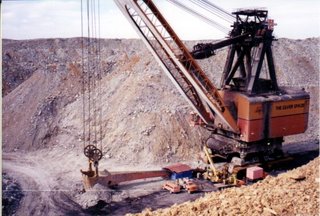
Apparently, Harrison County has a 7,000 ton Silver Spade on hand. Now, folks in Harrison think the giant earth-mover would be a great exhibit in a museum of mining history. An exhibit!? A far better use, in my humble opinion, would be my new personal around-the-town vehicle!
Now I know what some of you are thinking... You're thinking: "Steve, you're an idiot. This is not a very practical vehicle!"
Well, you're wrong. I consulted some reference information on the Silver Spade, and I'm convinced it would fit my transportation needs nicely. Now, obviously there are some drawbacks. At 85x64 feet, it takes up a full 5.3 standard highway lanes. Also, at 14,000,000 pounds, it exceeds highway limitations. (To be fair, the federal highway weight limitations are based on a per-axle weight of 20,000 lbs/axle, whereas the Silver Spade is driven on tank tracks; I'm not sure what the law is for transporting earth-moving equipment, but I think it still exceeds allowable weight by at least a few million pounds). Lastly, with a maximum speed of 0.25 miles per hour, it would take it roughly 96 hours to get me to work (I guess I could drive in and out on weekends). Oh yeah, parking it would also be difficult, although Wade Oval offers enough space.
But enough about the drawbacks! Let's focus on the advantages. First of all, I would have bragging rights of being the first guy on my block to own a Silver Spade. Also, I would be completely unaffected by traffic jams, since I could use the scoop to sweep 100 cars at a time out of my way (calculated at 3000 pounds per vehicle). And if the local gas station runs out of gas for my 14 separate engines, I could use the vehicle itself to start digging for my own oil. If any of my friends need a ride, I can certainly hook them up. Also, if for some reason firetrucks are called out to any of downtown's skyscrapers, I could reach anyone as high up as 200 feet.
The only problem, as I see it, is the estimated $30 million needed to get the Silver Spade back up and running. Though I have been diligently saving my money, I'm still a bit short. I'm still working on this issue...
Last of all, some of you may be wondering why I'm covering this issue at all in what until now has been an urban planning blog. What can I say? It's a fun mental exercise to imagine a totally different system of transportation. If you think through the practical aspects of driving a 7,000 ton vehicle around a city, it helps you understand the existing road system, as well as the way of life that is born of that system.
Anyway, I'm keeping my car for now.
Apparently, Harrison County has a 7,000 ton Silver Spade on hand. Now, folks in Harrison think the giant earth-mover would be a great exhibit in a museum of mining history. An exhibit!? A far better use, in my humble opinion, would be my new personal around-the-town vehicle!

Now I know what some of you are thinking... You're thinking: "Steve, you're an idiot. This is not a very practical vehicle!"
Well, you're wrong. I consulted some reference information on the Silver Spade, and I'm convinced it would fit my transportation needs nicely. Now, obviously there are some drawbacks. At 85x64 feet, it takes up a full 5.3 standard highway lanes. Also, at 14,000,000 pounds, it exceeds highway limitations. (To be fair, the federal highway weight limitations are based on a per-axle weight of 20,000 lbs/axle, whereas the Silver Spade is driven on tank tracks; I'm not sure what the law is for transporting earth-moving equipment, but I think it still exceeds allowable weight by at least a few million pounds). Lastly, with a maximum speed of 0.25 miles per hour, it would take it roughly 96 hours to get me to work (I guess I could drive in and out on weekends). Oh yeah, parking it would also be difficult, although Wade Oval offers enough space.
But enough about the drawbacks! Let's focus on the advantages. First of all, I would have bragging rights of being the first guy on my block to own a Silver Spade. Also, I would be completely unaffected by traffic jams, since I could use the scoop to sweep 100 cars at a time out of my way (calculated at 3000 pounds per vehicle). And if the local gas station runs out of gas for my 14 separate engines, I could use the vehicle itself to start digging for my own oil. If any of my friends need a ride, I can certainly hook them up. Also, if for some reason firetrucks are called out to any of downtown's skyscrapers, I could reach anyone as high up as 200 feet.
The only problem, as I see it, is the estimated $30 million needed to get the Silver Spade back up and running. Though I have been diligently saving my money, I'm still a bit short. I'm still working on this issue...
Last of all, some of you may be wondering why I'm covering this issue at all in what until now has been an urban planning blog. What can I say? It's a fun mental exercise to imagine a totally different system of transportation. If you think through the practical aspects of driving a 7,000 ton vehicle around a city, it helps you understand the existing road system, as well as the way of life that is born of that system.
Anyway, I'm keeping my car for now.
posted by Stephen Gross at
6:00 PM
2 Comments
![]()
![]()